C&A As-built 3D Surveys are able to capture significantly higher levels of detail, and therefore, accuracy regarding all aspects of an existing site. By choosing C&A to develop your 3D Survey, you will receive a highly accurate model of the site context and all of its’ surroundings, in a timely manner.
When compared with a traditional 2D survey, there is only a marginal increase in price, which this alone makes our 3D Surveys well worth the investment.
All our surveys use the latest in 3D laser scanning and BIM modelling technology, facilitating the rapid development of highly-accurate site plans, over what traditional 2D methods could ever achieve.
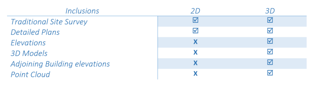
With a 3D Survey we are able to deliver site information, such as boundary offsets, vegetation and existing buildings, with far greater accuracy, which will be supplied directly to an architect or builder, in multiple file formats.
Conducting a 3D Survey ensures that the architect is not required to manually measure a site, or generate a 3D representation of the site in house prior to developing a new design concept. Rather, this frees up precious time to begin working on the project immediately.
Completing a Detailed Survey in 3D takes the guess work out of a project or specific site. This is in regards to accurate and detailed measurements of all objects found within a surveyed space. C&A Surveyors is able to deliver site information, such as boundary offsets, with far greater accuracy, which will be supplied directly to the architect. This means the architect doesn’t need to manually measure a site, or manually generate a 3D representation of the site themselves, in their architectural software.
Instead, they are supplied with a 3D model in various formats to suit all regularly used 3D design/ BIM software, along with all of the traditional 2D survey files that they would usually receive. This greatly reduces the architects modelling set-up time, saving them time, and you the customer money. This is all achieved, whilst ensuring a more accurate final output model to begin designing with, which has been built upon a highly-accurate initial data set.
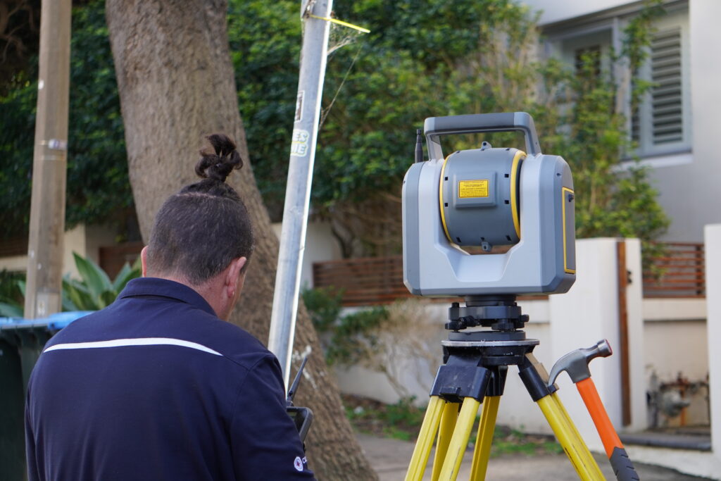
Our 3D scanners can record 300,000 points per second, for higher levels of detail, fidelity, and accuracy in the data we collect. Our in-house modelling team is then able to create a highly accurate 3D model by assigning each individual point with an easting, a northing and an elevation, which is equivalent to an X, Y and Z coordinate in 3D modelling software. Each of these points allow our team to then model in place, all of the other elements, structures and features of each site we survey.
The entire 3D Survey, and 3D modelling process is conducted In-house, ensuring that only the best quality is delivered to our clients. This includes the; scanning, data processing, 3D modelling, documentation drafting, and Quality Assurance procedures, which are implemented for every project.

Check out this short video with Sid Mokdassi, a long-term C&A customer, who explains how our 3D Surveys create a detailed representation of the data we have collected from his job sites. Sid explains how C&A 3D Surveys have helped his business, Zealous Consulting, improve both his turn around times and overall project workflow.
Please leave your details below and one of our 3D team will be in touch to talk though your project requirements, and ensure you receive the correct service for your needs.
A detail and level survey (also known as a contour survey) is the starting point of any design process. This survey picks up all existing features including trees, adjoining neighbours, visible services, easements and takes levels over the land. This survey also determines the location of the property boundaries and the existing buildings in relation to them.
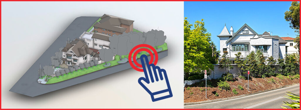
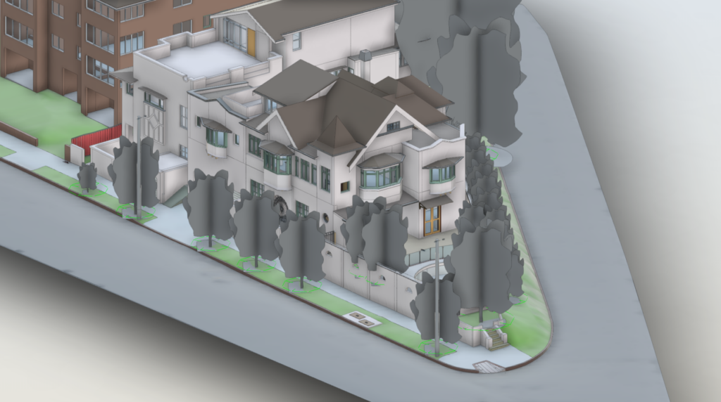
Now consider it being done as a 3D Survey, it will give you far greater detail and accuracy when compared to traditional 2D versions!A detail and level/identification survey picks up all existing features including trees, adjoining neighbour properties, visible services, and easements and takes levels over the land. In addition to this, the surveyor determines the location of the property boundaries and the existing buildings in relation to them.
Not getting enough details with a 2D Survey? Get it in 3D and see the difference! We can also utilise our drones to give you a clear picture of neighbouring structures, and any other services or features which are above your traditional line-of-site from the ground.
C&A Surveyors Sydney is an established family operated professional surveying services firm in Sydney. We have the leading 3D Surveyors in the industry with multiple years of experience.
Our clients can expect a dedicated one-point contact who will seamlessly manage the project from start to finish. This includes access to the 3D Survey prior to project sign off.
Our Sydney-based 3D Surveyors use leading 3D technology to produce highly accurate, reliable and efficient surveys, with all modelling and documentation completed in-house for added Quality Assurance.
Want a Professional Team with Reliable 3D Experience and Excellent Communication working with you? Get in touch with us today!
Call our team Directly on
Alternatively, Leave your details Below and we will be in touch!